



Relationship between immediate fire severity and medium-term post-fire vegetation cover: A case study in NW Spain
Cristina Fernández

*, Ana Novo
* Author to whom correspondence should be addressed.

Abstract
Assessing fire severity is crucial for planning post-fire management. However, few studies have examined the relationship between fire severity assessed immediately after wildfire and medium-term post-fire vegetation cover using field data. This study evaluated this relationship in 22 field plots located in shrublands (mainly Cytisus striatus and Pterospartum tridentatum) and Quercus pyrenaica stands affected by wildfires in NW Spain in 2020. Fire severity was assessed using dNBR, RdNBR and BNDVI, while vegetation cover was measured in the field four years after fire. RdNBR showed the strongest association with post-fire vegetation cover and was significantly correlated with total cover (rho = 0.68; p = 0.0005), shrub cover (rho = 0.45; p = 0.04) and tree cover (rho = 0.80; p < 0.0001). These results suggest that RdNBR may be a useful indicator of medium-term post-fire vegetation cover in these plant communities.Keywords
Fire severity, RdNBR, Sentinel-2, post-fire vegetation cover, shrublands1. Introduction
Fire severity, defined as the magnitude of the fire’s impact on vegetation and soil, is a key parameter for assessing ecological response and erosion risk (Keeley, 2009). Although most plant communities of the Mediterranean Basin have a high capacity to recover their composition and structure after wildfire due to their adaptive traits, i.e., resprouting capacity or serotiny (e.g. Keeley and Pausas, 2022), fire severity can significantly affect their post-fire recovery (Keeley et al., 2005; Vega et al., 2008). Vegetation fire severity and soil fire severity can affect the regenerative process through different ecological mechanisms. For example, in areas dominated by resprouters, it has been demonstrated that severe fires can damage belowground portions of shrubs or affect the bud bank limiting post-fire regeneration process (Enright et al., 2011) whereas, previous research in boreal forests has shown that soil burn severity positively affected seedling recruitment and post-fire vegetation recovery (Schimmel and Granstrom 1996; Johnstone and Kasischke, 2005). In shrubland communities under oceanic climate, high vegetation severity does not hamper the capacity of regeneration at the medium-term although the role played by the soil burn severity on the regenerative process of these resprouting species has been little explored and the results are inconclusive (Fernández et al., 2019; Fernández, 2023).
Spectral indices are generally used to assess fire severity immediately after fire (e.g., van Wagtendonk et al., 2004; Lentile et al., 2006; Fernández-Manso et al., 2016; Navarro et al., 2017; van Gerrevink and Veraverbeke, 2021; Sobrino et al., 2024) .The Normalized Burn Ratio (NBR) is the most commonly used index for post-wildfire severity mapping, and the differenced Normalized Burn Ratio (dNBR) is one of the most widely used vegetation indices to evaluate changes between pre-fire and post-fire conditions (e.g., Key and Benson, 2006; Veraverbeke et al., 2010; Llorens et al., 2021). The RdNBR (Miller and Thode, 2007) is also commonly used as it has been demonstrated its good performance in areas with high vegetation heterogeneity (e.g. Lydersen et al., 2016). Recently, other indices such as the Blue Normalized Difference Vegetation Index (BNDVI) showed its performance for soil burn severity evaluation (Novo et al., 2024).
Post-fire vegetation recovery has been mostly evaluated through multi-temporal satellite observations, allowing the characterization of vegetation resilience and recovery trajectories across different ecosystems (e.g., Röder et al., 2008; van Leeuwen et al., 2010; Fernández-Manso et al., 2016; Viana-Soto et al., 2020; Pérez-Cabello et al., 2020; Anees et al., 2025). However, and despite the widespread application of remote sensing for fire severity assessment and post-fire monitoring, few studies have evaluated whether fire severity indices derived immediately after fire are significantly associated with field-measured post-fire vegetation cover several years later, particularly in shrublands dominated by resprouting species where vegetation resilience is typically high. Understanding how vegetation recovers after fire, and particularly, the quantitative relationship between post-fire vegetation cover and initial fire severity is crucial for restoration plans. Long-term measurements of post-fire vegetation recovery for differing forest types and fire severity levels can be useful to identity areas where post-fire intervention is necessary. The use of spectral indices could serve to provide a quantitative value of fire severity and determine whether the severity immediately after a fire is related to the regeneration of the assessed vegetation. Therefore, the aim of this study was to evaluate whether vegetation and soil fire severity, measured immediately after fire, influence vegetation cover at the medium-term.
2. Experimental design and field sampling
The study was carried out in two contiguous areas affected by wildfire in NW Spain (Figure 1). The wildfires burned over 2000 ha of shrublands and forest stands in July 2020. Just after fire, 22 field plots were distributed in the burned areas trying to reflect the variability in fire severity.
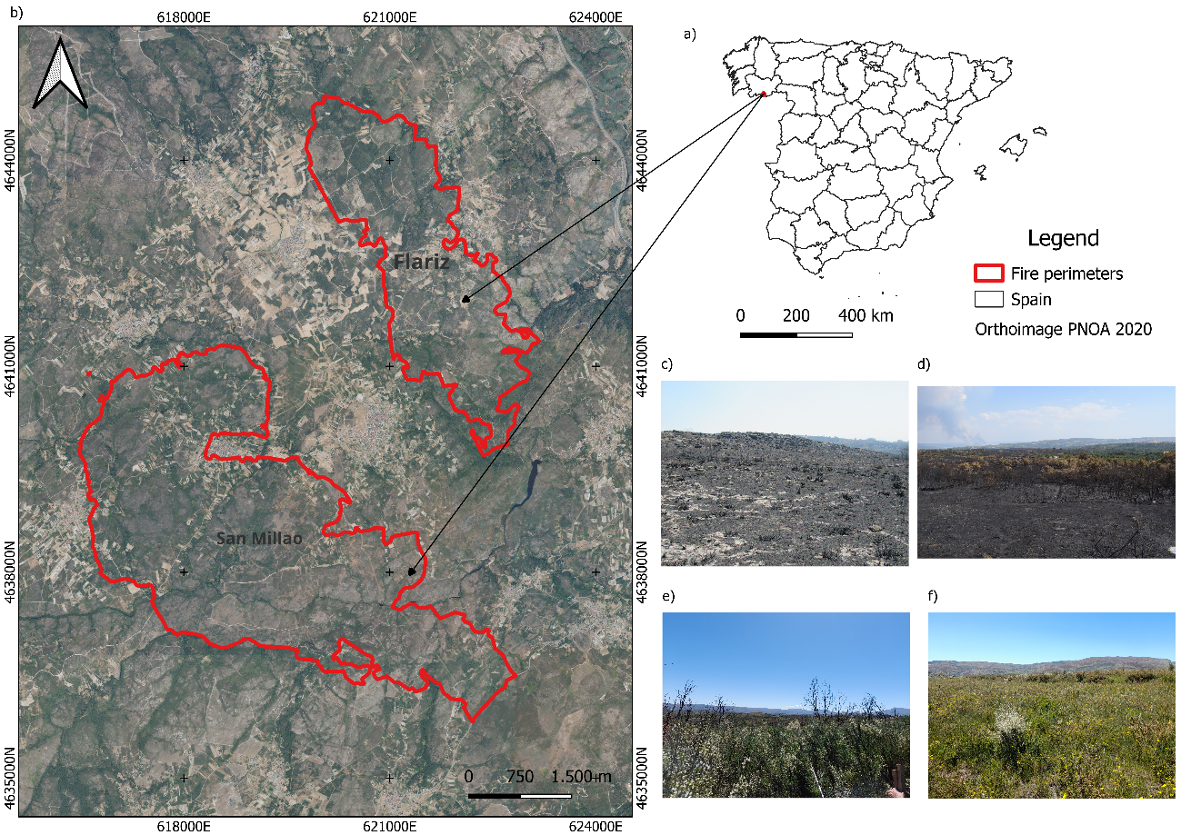
Figure 1: a) Location of the study sites in NW Spain; b) Fire perimeters of the San Millao and Flariz wildfires; (c-f) representative field of post-fire conditions (year 2020); and (e-f) post-fire vegetation conditions at the time of field sampling (year 2024). The map coordination system is ETRS89/UTM zone 29N (EPSG:25829).
2.1. Field sampling
The surveyed vegetation types were immature Quercus pyrenaica Willd. stands regenerated from previous fires and shrublands dominated by Cytisus striatus (Hill) Rothm. or Pterospartum tridentatum (L.) Willk. as they were the most common vegetation communities in the burned areas. For each site, the plot center was geolocated using a Global Navigation Satellite System (GNSS), from which two 40 m transects were established coinciding with the plot center. Field data collection was conducted as soon as possible after fire extinction. The procedure, adapted from Fernández et al. (2021) was based on a visual assessment of post-fire vegetation structure. Vegetation burn severity (VBS) was classified in two levels (moderate and high) depending on biomass consumption: moderate when vegetation foliage was charred and high when it was totally consumed. In each plot, we also assessed soil burn severity with the aid of a 20 cm × 20 cm quadrat, which was placed at 80 systematically selected points along the transects. The soil in each quadrat was classified following Fernández and Vega (2016). The main characteristics of the field plots are compiled in Table 1.
Table 1: Mean fire severity in the field plots.
| Vegetation type | Vegetation burn severity | Soil burn severity |
| Quercus pyrenaica (10 plots) | Moderate to high | Low to High |
| Shrubland (12 plots) | High | Low to High |
In the spring of 2024, vegetation characteristics were measured in the same plots where the fire severity evaluation was carried out. Cover by all species present was measured for each transect using the line intercept method (Canfield, 1941). Trees, shrubs, and grass cover and also total vegetation cover were calculated for each plot. Total cover was determined by adding up the covers of all species so the final value may exceed 100%.
2.2. Spectral indices
We calculated the spectral indices using data from Sentinel-2 satellite provided by the European Space Agency (ESA). Sentinel-2 is a constellation of two satellites providing high-resolution multispectral optical imagery. All study images used were downloaded from the ESA website (Copernicus Open Access Hub, https://scihub.copernicus.eu/dhus/#/home) and were Level 2A (bottom of atmosphere) reflectance images, which are atmospherically corrected.
To assess the spectral indices, Sentinel-2 Level-2A data were downloaded from the Copernicus browser platform (https://browser.dataspace.copernicus.eu/). Images were acquired as close as possible to the date of the field fire severity assessment, and were selected to ensure limited cloud cover (<5%) over the study areas. Prefire and postfire image acquisition dates were T29TPG_20200708T112121 and T29TPG_20200906T112121, respectively.
Four spectral indices were selected due to their demonstrated robustness and generalization ability to assess fire severity in different scenarios. Indices were computed at 20 m of spatial resolution. For each sampling point, a 40 x 40 m area was analyzed, and the mean pixel value was calculated for each index.
The dNBR and its relativised form, the RdNBR, both derived from the NBR proposed by Key and Benson (2006) where computed as follows:
![\[ \text{NBR} = \frac{\text{NIR} - \text{SWIR}}{\text{NIR} + \text{SWIR}} \qquad (1) \]](https://www.recentadvancesin.com/wp-content/ql-cache/quicklatex.com-d56b6d62df1e19d9f7968d2e1d85e0be_l3.png "Rendered by QuickLaTeX.com")
![\[ \text{dNBR} = \text{NBR}_{\text{pre}} - \text{NBR}_{\text{post}} \qquad (2) \]](https://www.recentadvancesin.com/wp-content/ql-cache/quicklatex.com-1afd5c3904b37ded06bba8acab2d7910_l3.png "Rendered by QuickLaTeX.com")
Where NIR (Eq. 1) correspond to band 8 and SWIR (Eq. 1) to band 12 of Sentinel-2 satellite.
The RdNBR, introduced by Miller and Thode (2007), adjusts dNBR by the magnitude of pre-fire NBR values and, were calculated following Eq. 3.
![\[ \text{RdNBR} = \frac{\text{dNBR}}{\sqrt{\left| \text{NBR}_{\text{pre}} \right|}} \qquad (3) \]](https://www.recentadvancesin.com/wp-content/ql-cache/quicklatex.com-fe15d4bebde912f0b643796fb5e0aef5_l3.png "Rendered by QuickLaTeX.com")
The BNDVI proposed by Wang et al. (2007) is defined as Eq. 4.
![\[ \text{BNDVI} = \frac{\text{NIR} - \text{BLUE}}{\text{NIR} + \text{BLUE}} \qquad (4) \]](https://www.recentadvancesin.com/wp-content/ql-cache/quicklatex.com-99dcc6cdcdf2c34e8eebc18440a3bafd_l3.png "Rendered by QuickLaTeX.com")
The mean value of each index was obtained for each field plot.
2.3. Statistical analyses
Spearman’s rank correlation was used to evaluate the strength and direction of the association between multispectral indices and vegetation variables. The R statistical package (Version 4.4.1.) was used to conduct the statistical analyses.
3. Results
The evaluation of fire severity immediately after fire (July 2020) showed that RdNBR and BNDVI were the best indices to indicate vegetation burn severity and soil burn severity, respectively (Table 2).
Table 2: Spearman rank correlation coefficients between spectral and field fire severity indices
| dNBR | RdNBR | BNDVI | |
| Vegetation burn severity | 0.521 (p=0.01) | 0.624 (p=0.002) | -0.470 (p=0.03) |
| Soil burn severity | 0.368 (p=0.09) | 0.585 (p=0.004) | -0.737 (p< 0.0001) |
The vegetation parameters obtained in the surveys performed in the fourth spring after fire are summarized in Table 3. The shrubs were the vegetative group showing the highest post-fire cover.
Table 3: Mean and range of variation of the vegetation parameters measured in April 2024
| Total vegetation cover (%) | Shrub cover (%) | Tree cover (%) | Grass cover (%) | |
| Mean | 161.4 | 105.2 | 2.7 | 53.6 |
| Range of variation | 73.0-284.6 | 50.0-210.7 | 0.0-11.5 | 0.0-170.0 |
No significant correlations were found between dNBR or BNDVI and the vegetation parameters.
RdNBR showed the strongest association with post-fire vegetation cover four years after fire (Figure 2). The index was significantly correlated with total cover (rho = 0.68; p = 0.0005), shrub cover (rho = 0.45; p = 0.04) (Figure 3) and tree cover (rho = 0.80; p < 0.0001) (Figure 4).
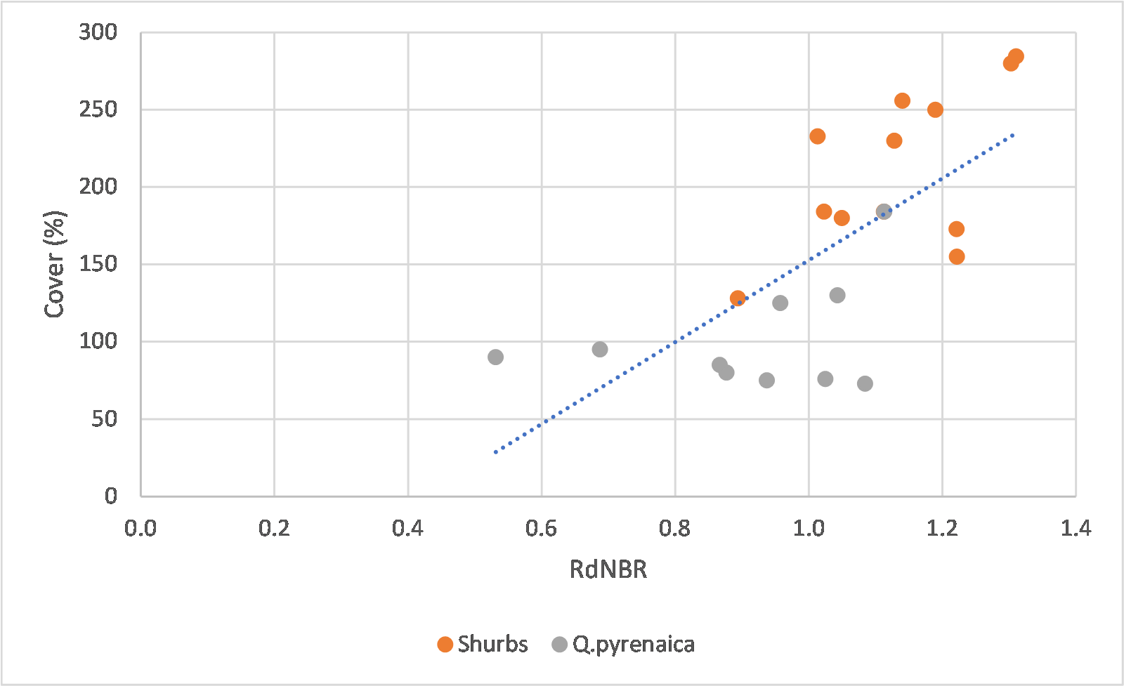
Figure 2: Relationship between the RdNBR index and total cover percentage. The lines represent the fitted relationship.
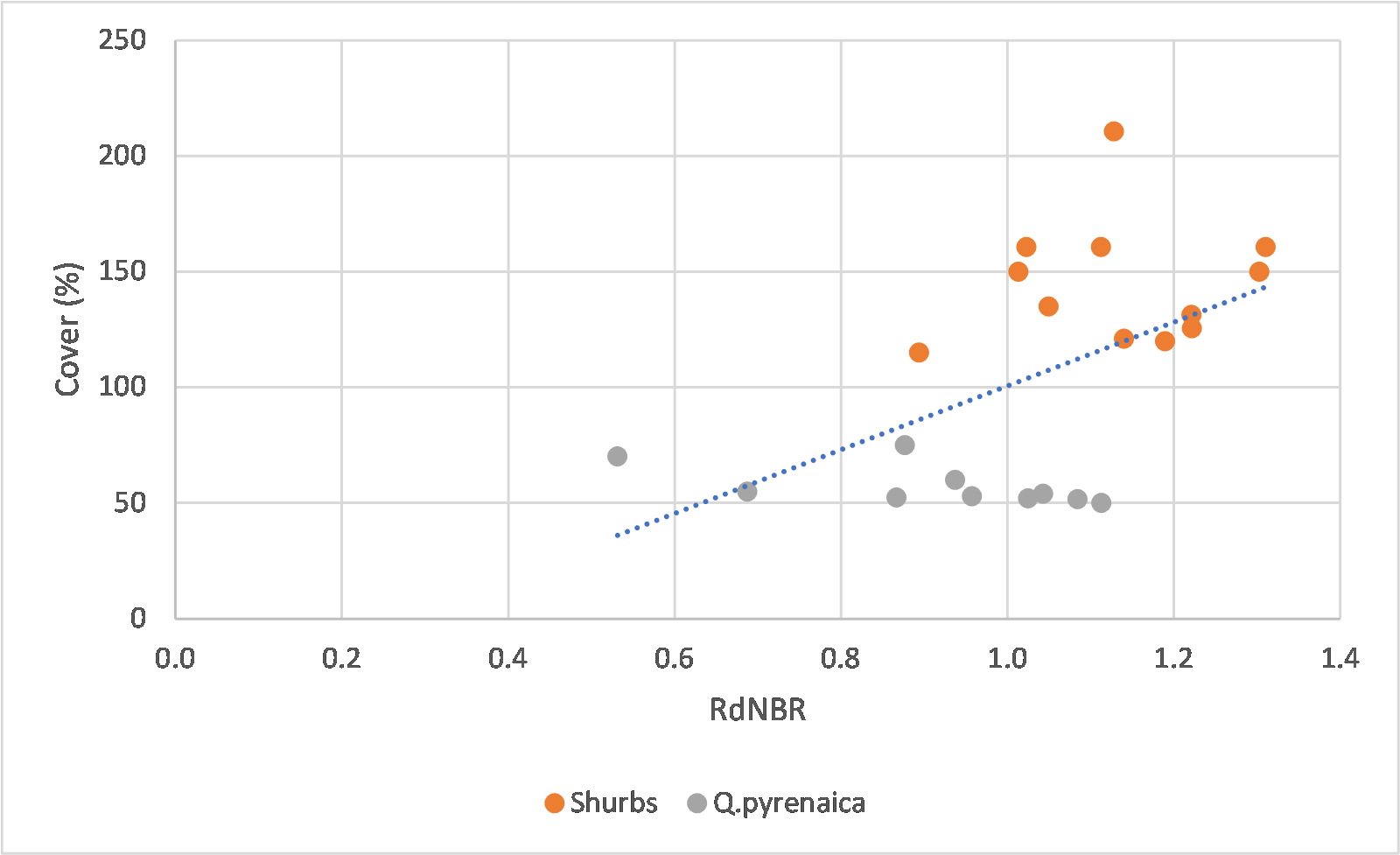
Figure 3: Relationship between the RdNBR index and the shrub cover percentage. The lines represent the fitted relationship.
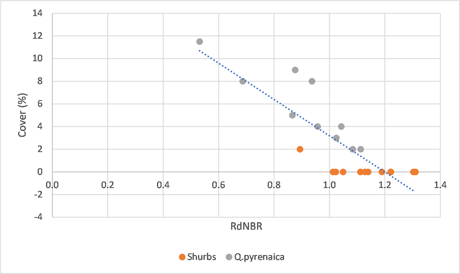
Figure 4: Relationship between the RdNBR index and the tree cover percentage. The lines represent the fitted relationship.
According to Figure 3, vegetation cover increases with RdNBR, with lower values when RdNBR was less than 0.84 and maximum when it when it exceeded 1.14. The RdNBR thresholds of 0.84 and 1.14 were selected based on visual inspection of the relationship between RdNBR and post-fire vegetation cover. Consequently, we reclassified the RdNBR the two study sites (Figure 5), showing the differences in vegetation cover. This provides a different perspective compared to the fire severity assessment following the levels proposed by Miller and Thode (2007) that is shown in Figure 6.
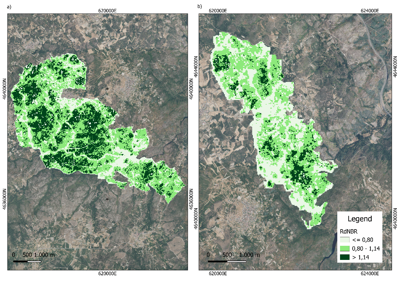
Figure 5: Spatial distribution of the RdNBR in the (a) San Millao and (b) Flariz wildfire perimeters reclassified following vegetation cover in 2024.
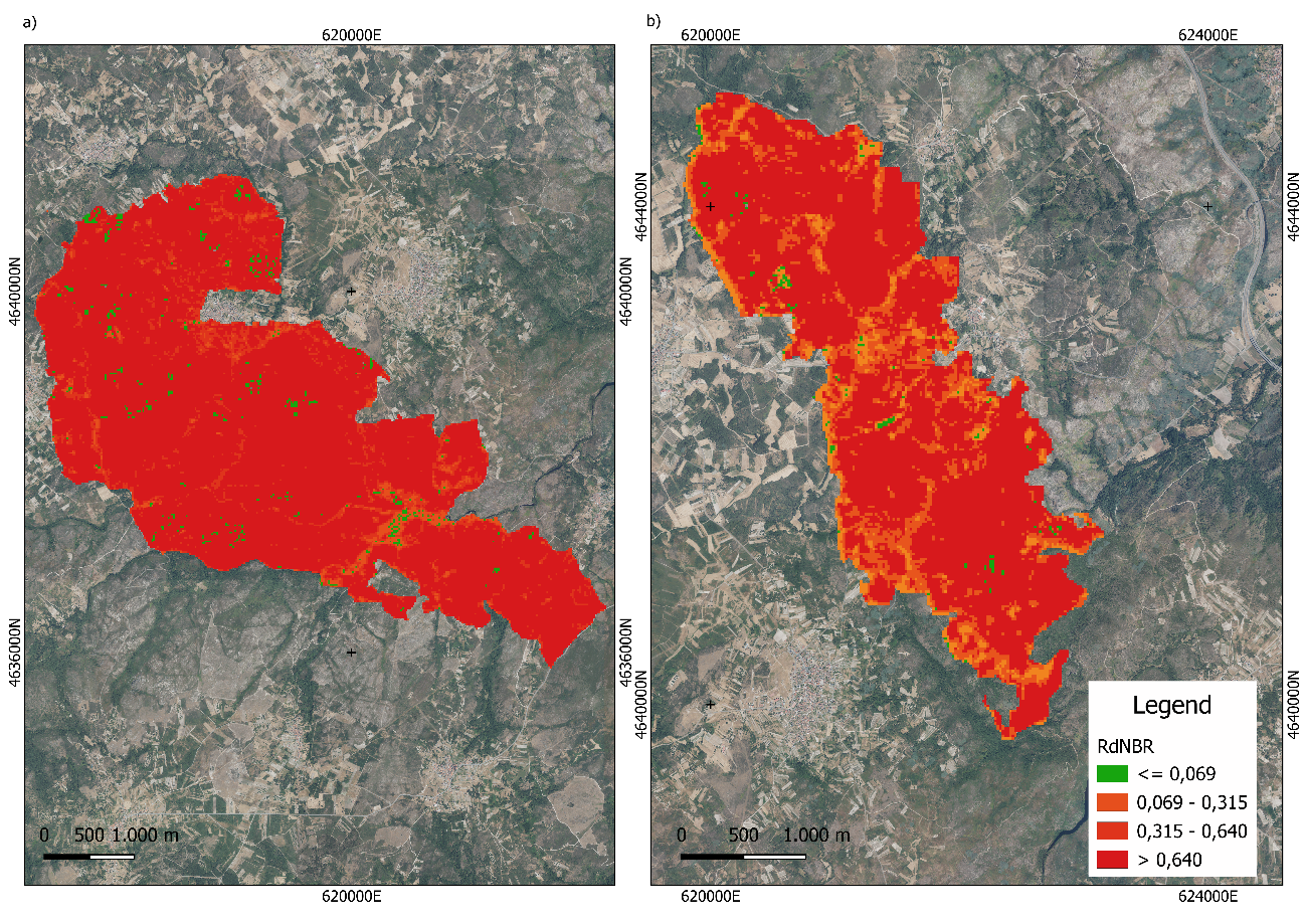
Figure 6: Spatial distribution of the RdNBR in the (a) San Millao and (b) Flariz wildfire perimeters with the fire severity levels proposed by Miller and Thode (2007).
4. Discussion
The level of post-fire vegetation cover observed in the field plots were similar to those observed after wildfire in shrubland communities in NW Spain (Fernández, 2021). The high post-fire vegetation cover observed may be related to the high resprouting capacity of Atlantic shrubland communities, where post-fire regeneration is primarily driven by vegetative resprouting rather than seed recruitment (Keeley and Pausas, 2022). Interestingly, tree cover four years after fire was positively associated with RdNBR (rho = 0.80; p < 0.0001), indicating greater tree cover at higher initial fire severity, in contrast to previous observations in NW Spain (Vega et al., 2005; Fernández, 2022). This positive relationship may reflect the high resprouting capacity of Q. pyrenaica, suggesting that higher initial fire severity did not constrain tree dover four years after fire.Fire severity assessment using multispectral indices showed that the performance of the indices is different depending on whether fire severity is evaluated in the vegetation or in the soil and regarding soil burn severity, BNDVI seems to be the best option as previously observed by Novo et al. (2024). Our results showed that the RdNBR is a more effective index for vegetation burn severity mapping as previously found in different ecosystems (Miller and Thode, 2007; De Santis et al., 2010; Quintano et al., 2018; Dos Santos et al., 2020). For instance, Miller and Thode (2007) demonstrated that classifications of the RdNBR can produce higher accuracies for the high severity category than the dNBR, as in the present case of study. In the present study, the underrepresentation of the moderate severity class precludes us to provide vegetation severity thresholds, but the highest severity level was established above 1.0, clearly higher than the 0.640 and 0.732 values proposed by Miller and Thode (2007) or Lydersen et al. (2016). These differences likely reflect the contrasting vegetation structure compared with the conifer forests where those thresholds were originally developed. Given the limited number of field plots, the thresholds identified in this study should be considered exploratory and site-specific and should not be extrapolated to other areas without further validation.
Although several studies have subsequently used burn severity maps derived from RdNBR or dNBR to analyse vegetation recovery (Díaz-Delgado et al., 2003; Meng et al., 2018; Dos Santos et al., 2020; Kim et al., 2021; Zahabnazouri et al., 2025), vegetation trajectories have been generally quantified using remotely sensed vegetation indices such as NDVI, SAVI, NIRv or EVI instead of field data. By contrast, this study relates RdNBR measured immediately after wildfire to vegetation cover measured directly in the field four years later. Until now, most of the immediate fire severity evaluation carried out in NW Spain was related to the assessment of the impact of wildfire for post-fire soil stabilization planning (e.g. Sobrino et al., 2019; Novo et al., 2024). No information was available on how fire severity is related to post-fire vegetation cover in the medium-term. The results obtained in the present study show how RdNBR may be a useful indicator of not only the immediate impact of the fire but also medium-term post-fire vegetation cover in these communities.
The influence of BNDVI, as a surrogate of soil burn severity, on the regenerative process seems less significant. This is consistent with the results obtained by Fernández et al. (2019) and Fernández (2021) who stated that the vegetative recovery was not influenced by soil burn severity in communities dominated by resprouters.
5. Conclusions
Although the relatively small dataset used in this study prevents us from drawing broad conclusions, the results obtained in this study seem to indicate that RdNBR computed immediately after fire was significantly associated with medium-term post-fire vegetation cover, although further studies with larger datasets are needed to assess the genrality of this relationship. Future studies including a wider range of fire severities, vegetation communities and environmental conditions would help validate the robustness and transferability of this relationship.
Author Contributions
Cristina Fernández: Funding acquisition, Project administration, Resources, Supervision, Conceptualization, Methodology, Validation, Formal analysis, Investigation, Data Curation, Writing– Original Draft , Writing- Review & Editing.
Ana Novo: Methodology, Software, Validation, Formal analysis, Investigation, Data Curation, Writing– Original Draft.
Declaration of Competing Interest
The authors declare that they have no known competing financial interests or personal relationships that could have appeared to influence the work reported in this paper.
Acknowledgements
We are grateful to all those who helped with fieldwork, particularly, J. Pardo, I. Losada and D. Vázquez.
Funding
This research was funded by the Spanish Research Agency of the Spanish Ministry of Science and Innovation through project ENFIRES-NW-PID2020-116494RR-C42.
References
Anees SA, Mehmood K, Luo M, et al (2025) Advancing forest fire burn severity and vegetation recovery assessments using remote sensing and machine learning approaches. Ecol Inform 92:. https://doi.org/10.1016/j.ecoinf.2025.103446
Canfield RH (1941) Application of the Line Interception Method in Sampling Range Vegetation. J For 39:388–394. https://doi.org/10.1093/jof/39.4.388
De Santis A, Asner GP, Vaughan PJ, Knapp DE (2010) Mapping burn severity and burning efficiency in California using simulation models and Landsat imagery. Remote Sens Environ 114:1535–1545. https://doi.org/10.1016/j.rse.2010.02.008
Díaz-Delgado R, Lloret F, Pons X (2003) Influence of fire severity on plant regeneration by means of remote sensing imagery. Int J Remote Sens 24:1751–1763. https://doi.org/10.1080/01431160210144732
Dos Santos SMB, Bento-Gonçalves A, Franca-Rocha W, Baptista G (2020) Assessment of burned forest area severity and postfire regrowth in chapada diamantina national park (Bahia, brazil) using dnbr and rdnbr spectral indices. Geosciences (Switzerland) 10:. https://doi.org/10.3390/geosciences10030106
Enright NJ, Fontaine JB, Westcott VC, et al (2011) Fire interval effects on persistence of resprouter species in Mediterranean-type shrublands. Plant Ecol 212:2071–2083. https://doi.org/10.1007/s11258-011-9970-7
Fernández C (2021) Medium-term effects of straw helimulching on post-fire vegetation recovery in shrublands in north-west Spain. Int J Wildland Fire 30:301–305. https://doi.org/10.1071/WF20092
Fernández C (2022) Influencia de la aplicación de mulching para el control de la erosión post-incendio en la capacidad de rebrote de Q. pyrenaica Willd. 8 Congreso Forestal Español. Lleida
Fernández C (2023) Soil fire severity is more relevant than fire frequency in explaining soil, carbon and nitrogen losses and vegetation recovery after wildfire in NW Spain. J Environ Manage 327:116876. https://doi.org/10.1016/j.jenvman.2022.116876
Fernández C, Vega JA (2016) Modelling the effect of soil burn severity on soil erosion at hillslope scale in the first year following wildfire in NW Spain. Earth Surf Process Landf 41:928–935. https://doi.org/10.1002/esp.3876
Fernández C, Vega JA, Fontúrbel T (2019) Does helimulching after severe wildfire affect vegetation recovery in a coastal area of Northwest Spain? Landscape and Ecological Engineering 15:337–345. https://doi.org/10.1007/s11355-019-00386-7
Fernández C, Fernández-Alonso J M, Keizer JJ, Girona-García A (2021) Guía para la evaluación de campo de la severidad del fuego en el suelo. Xunta de Galicia. ISBN: 978-84-124269-3-9
Fernández-Manso A, Quintano C, Roberts DA (2016) Burn severity influence on post-fire vegetation cover resilience from Landsat MESMA fraction images time series in Mediterranean forest ecosystems. Remote Sens Environ 184:112–123. https://doi.org/10.1016/j.rse.2016.06.015
Johnstone JF, Kasischke ES (2005) Stand-level effects of soil burn severity on postfire regeneration in a recently burned black spruce forest. In: Canadian Journal of Forest Research. pp 2151–2163
Keeley JE (2009) Fire intensity, fire severity and burn severity: a brief review and suggested usage. Int J Wildland Fire 18:116–126
Keeley JE, Fotheringham CJ, Baer-Keeley M (2005) Determinants of postfire recovery and succession in Mediterranean-climate shrublands of California. Ecological Applications 15:1515–1534. https://doi.org/10.1890/04-1005
Keeley JE, Pausas JG (2022) Evolutionary Ecology of Fire. Annual Review of Ecology, Evolution, and Systematics. Vol. 53:203-225 https://doi.org/10.1146/annurev-ecolsys-102320-095612
Key CH, Benson NC (2006) Landscape assessment (LA). In: Lutes, Duncan C; Keane, Robert E; Caratti, John F; Key, Carl H; Benson, Nathan C; Sutherland, Steve; Gangi, Larry J 2006 FIREMON: Fire effects monitoring and inventory system Gen Tech Rep RMRS-GTR-164-CD Fort Collins, CO: US Department of 164:
Kim Y, Jeong MH, Youm M, et al (2021) Recovery of forest vegetation in a burnt area in the republic of Korea: A perspective based on sentinel-2 data. Applied Sciences 11:. https://doi.org/10.3390/app11062570
Lentile LB, Holden ZA, Smith AMS, et al (2006) Remote sensing techniques to assess active fire characteristics and post-fire effects. Int J Wildland Fire 15:319–345. https://doi.org/10.1071/WF05097
Llorens R, Sobrino JA, Fernández C, et al (2021) A methodology to estimate forest fires burned areas and burn severity degrees using Sentinel-2 data. Application to the October 2017 fires in the Iberian Peninsula. International Journal of Applied Earth Observation and Geoinformation 95:. https://doi.org/10.1016/j.jag.2020.102243
Lydersen JM, Collins BM, Miller JD, et al (2016) Relating fire-caused change in forest structure to remotely sensed estimates of fire severity. Fire Ecology 12:99–116. https://doi.org/10.4996/fireecology.1203099
Meng R, Wu J, Zhao F, et al (2018) Measuring medium-term post-fire forest recovery across a burn severity gradient in a mixed pine-oak forest using multi-sensor remote sensing techniques. Remote Sens Environ 210:282–296. https://doi.org/10.1016/j.rse.2018.03.019
Miller JD, Thode AE (2007) Quantifying burn severity in a heterogeneous landscape with a relative version of the delta Normalized Burn Ratio (dNBR). Remote Sens Environ 109:66–80. https://doi.org/10.1016/j.rse.2006.12.006
Navarro G, Caballero I, Silva G, et al (2017) Evaluation of forest fire on Madeira Island using Sentinel-2A MSI imagery. International Journal of Applied Earth Observation and Geoinformation 58:97–106. https://doi.org/10.1016/j.jag.2017.02.003
Novo A, Fernández C, Míguez C, Suárez-Vidal E (2024) Analysing the capacity of multispectral indices to map the spatial distribution of potential post-fire soil losses based on soil burn severity. Ecol Inform 83:. https://doi.org/10.1016/j.ecoinf.2024.102793
Pérez-Cabello F, Montorio R, Alves DB (2021) Remote sensing techniques to assess post-fire vegetation recovery. Curr Opin Environ Sci Health 21:100251. https://doi.org/10.1016/j.coesh.2021.100251
Quintano C, Fernández-Manso A, Fernández-Manso O (2018) Combination of Landsat and Sentinel-2 MSI data for initial assessing of burn severity. International Journal of Applied Earth Observation and Geoinformation 64:221–225. https://doi.org/10.1016/j.jag.2017.09.014
Röder A, Hill J, Duguy B, et al (2008) Using long time series of Landsat data to monitor fire events and post-fire dynamics and identify driving factors. A case study in the Ayora region (eastern Spain). Remote Sens Environ 112:259–273. https://doi.org/10.1016/j.rse.2007.05.001
Schimmel J, Granstrom A (1996) Fire Severity and Vegetation Response in the Boreal Swedish Forest. Ecology 77:1436–1450. https://doi.org/10.2307/2265541
Sobrino JA, Llorens R, Fernández C, et al (2019) Relationship between forest fires severity measured in situ and through remotely sensed spectral indices. Forests 10:. https://doi.org/10.3390/f10050457
Sobrino JA, Llorens R, Fernández C, et al (2024) Methodology for burned areas delimitation and fire severity assessment using Sentinel-2 data. A case study of forest fires occurred in Spain between 2018 and 2023. Recent Advances in Remote Sensing 1–13. https://doi.org/10.62880/rars240002
The R Foundation for Statistical Computing (2024) R version 4.4.1
van Gerrevink MJ, Veraverbeke S (2021) Evaluating the near and mid infrared bi-spectral space for assessing fire severity and comparison with the differenced normalized burn ratio. Remote Sens (Basel) 13:1–19. https://doi.org/10.3390/rs13040695
Van Leeuwen WJD, Casady GM, Neary DG, et al (2010) Monitoring post-wildfire vegetation response with remotely sensed time-series data in Spain, USA and Israel. Int J Wildland Fire 19:75–93. https://doi.org/10.1071/WF08078
van Wagtendonk JW, Root RR, Key CH (2004) Comparison of AVIRIS and Landsat ETM+ detection capabilities for burn severity. Remote Sens Environ 92:397–408. https://doi.org/10.1016/j.rse.2003.12.015
Vega J.A,; Pérez-Gorostiaga P; Fontúrbel, T., , Barreiro, A, Fernández C, Cuiñas P (2005) Variables influyentes en la respuesta regenerativa vegetativa a corto plazo de Quercus pyrenaica Willd. tras incendios en Galicia. In: IV Congreso Forestal Español
Vega JA, Fernández C, Pérez-Gorostiaga P, Fonturbel T (2008) The influence of fire severity, serotiny, and post-fire management on Pinus pinaster Ait. recruitment in three burnt areas in Galicia (NW Spain). For Ecol Manage 256:1596–1603. https://doi.org/10.1016/j.foreco.2008.07.005
Veraverbeke S, Lhermitte S, Verstraeten WW, Goossens R (2010) The temporal dimension of differenced Normalized Burn Ratio (dNBR) fire/burn severity studies: The case of the large 2007 Peloponnese wildfires in Greece. Remote Sens Environ 114:2548–2563. https://doi.org/10.1016/j.rse.2010.05.029
Viana-Soto A, Aguado I, Salas J, García M (2020) Identifying post-fire recovery trajectories and driving factors using landsat time series in fire-prone mediterranean pine forests. Remote Sens (Basel) 12:. https://doi.org/10.3390/RS12091499
Wang F, Huang J, Tang Y, Wang X (2007) New vegetation index and its application in estimating leaf area index of rice. Rice Sci 14:195–203
Zahabnazouri S, Belmont P, David S, et al (2025) Detecting Burn Severity and Vegetation Recovery After Fire Using dNBR and dNDVI Indices: Insight from the Bosco Difesa Grande, Gravina in Southern Italy. Sensors 25:. https://doi.org/10.3390/s25103097
Publisher’s Note
The statements, opinions, and data contained in all publications are solely those of the individual author(s) and contributor(s) and not of Recent Advances S.L. and/or the editor(s). Recent Advances S. L. and/or the editor(s) disclaim responsibility for any injury to people or property resulting from any ideas, methods, instructions, or products referred to in the content.