



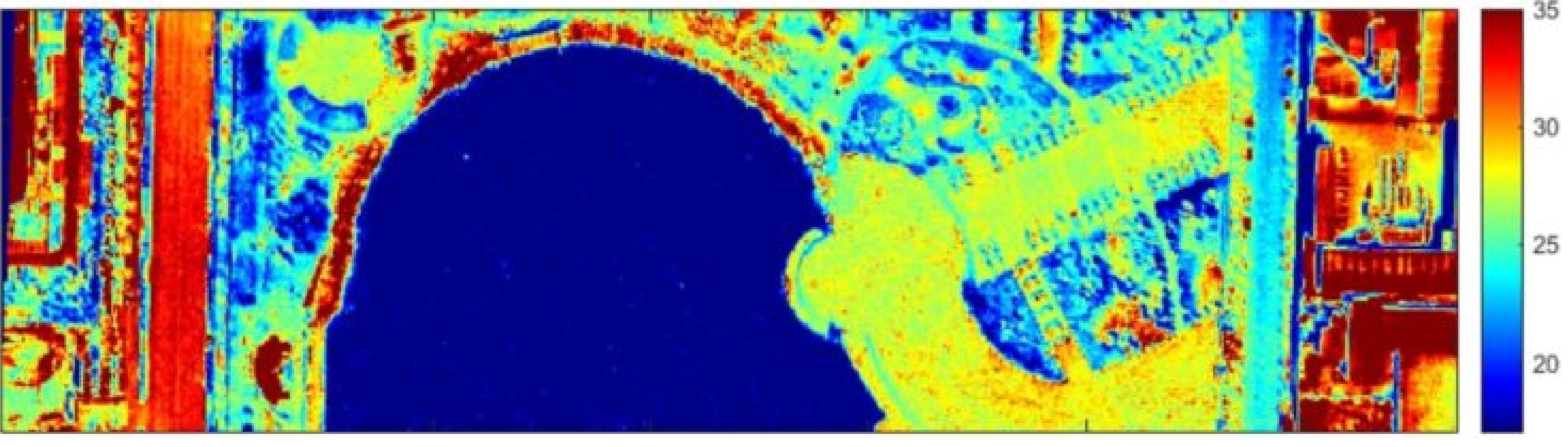
A Statistical Split Window Method Without Atmospheric Profile Input for Temperature and Emissivity Retrieval from Airborne Long-Wavelenght Infrared Hyperspectral Imagery
Du Wang

1, Lyuzhou Gao
2,3,Yanfei Zhong
1, Liqin Cao
4*- State Key Laboratory of Information Engineering in Surveying, Mapping and Remote Sensing, Wuhan University, Wuhan, 430072, China.
- National Institute of Natural Hazards, Ministry of Emergency Management of the People’s Republic of China, Beijing, 100085, China.
- Key Laboratory of Compound and Chained Natural Hazards Dynamics, Beijing, 100085, China.
- School of Resource and Environmental Sciences, Wuhan University, Wuhan, 430079, China.
* Author to whom correspondence should be addressed.

Abstract
The retrieval of Land Surface Temperature (LST) and Emissivity (LSE) from long-wavelength thermal infrared (LWIR) hyperspectral data can be challenging due to uncertainties in atmospheric compensation (AC). While AC is typically performed using atmospheric radiance models, errors in the input atmospheric profiles can lead to significant inaccuracies. In this study, we propose an end-to-end method for retrieving LST and LSE without the need for local atmospheric profile inputs. The method consists of two main steps: first, a statistical split-window (SSW) method is used to estimate the ground leaving radiance, with optimal band configurations and coefficients determined through a trial-and-error approach and statistical regression based on simulation datasets. Second, by integrating the ASTER Temperature And Emissivity Separation (ASTER-TES) method with an atmospheric downwelling lookup table (LUT), the optimal LST and LSE are derived based on the principle of emissivity smoothness. The proposed method is applied to airborne HypercamLW LWIR hyperspectral data. When compared to the MODTRAN-based AC with ASTER-TES (MODTRAN-TES) and the built-in method of FLAASH-IR, the proposed SSW-TES method yields better accuracy, with a LST root mean square error (RMSE) of 1.24 K and an LSE RMSE of 0.016.Keywords
Thermal infrared hyperspectral, Temperature and emissivity retrieval, atmospheric compensation, split window1. Introduction
Land Surface Temperature (LST) and Emissivity (LSE) are critical physical parameters for analyzing and modeling the Earth’s surface (Manolakis et al., 2019). LST and LSE represent the thermal properties and types of land surfaces, respectively, and together they influence the radiance emitted from the ground. Given the limited availability of open-access long-wavelength infrared (LWIR) hyperspectral data, most current studies focus on developing LST retrieval methods using satellite- based multispectral data (Li et al., 2013), which typically underutilize LSE information. In recent years, the development of airborne LWIR hyperspectral sensors has provided abundant spectral data, enabling the simultaneous retrieval of both LST and LSE. Atmospheric compensation (AC) based on atmospheric models is commonly employed to first remove atmospheric interference from the radiance measured by the sensor. Then, Temperature and Emissivity Separation (TES) methods can be applied to decouple LST and LSE from the ground-leaving radiance (Ren et al., 2020). However, the limited accuracy of the in-scene atmospheric profiles can introduce significant uncertainty in atmospheric compensation, leading to errors that accumulate in the retrieved LST and LSE values (Wang et al., 2024).
In this study, a statistical split-window method combined with ASTER-TES (SSW-TES) is proposed. Compared to traditional methods such as MODTRAN-TES, which rely on additional atmospheric profile inputs, and FLAASH-IR, which depends on a limited atmospheric parameter library, the proposed approach offers greater flexibility in processing airborne thermal infrared hyperspectral images of diverse conditions. This is because the SSW-TES method enables direct retrieval of temperature and emissivity without prior atmospheric or surface information. The accuracy of the proposed method is validated using airborne data collected from the HypercamLW thermal infrared hyperspectral imager, with ground truth data for temperature and emissivity obtained synchronously during the flight.
2. Method
The workflow of the proposed method is illustrated in Figure 1. The input phase primarily involves the preparation of simulated at-sensor radiance and ground-leaving radiance. The simulation dataset accounts for various atmospheric and land surface conditions, with all simulated radiance spectra resampled to match the exact spectral resolution of the HypercamLW data used in the study. The next step is the retrieval module, which employs the SSW-TES method. This module consists of two key subsections: first, the optimal band configuration for estimating ground-leaving radiance is developed using the simulation dataset. This configuration is then applied to the HypercamLW data. Following the ground-leaving radiance estimation in the SSW sub-module, the LST and LSE of the target data are calculated using the ASTER-TES algorithm, guided by the principle of emissivity smoothness.
Under clear sky conditions, the at-sensor radiance can be formulated into a radiative transfer equation (RTE) as follows:
![\[ L_i = \tau_i \left( \epsilon_i B(T)_i + (1 - \epsilon_i) L_D_i) + L_U_i \quad (1)\]](https://www.recentadvancesin.com/wp-content/ql-cache/quicklatex.com-734f2977fec91f5fe86c717419dbe213_l3.png "Rendered by QuickLaTeX.com")
 is the atmospheric transmittance,
  is LSE, B(T) is Planck’s blackbody radiance of LST in Kelvin,
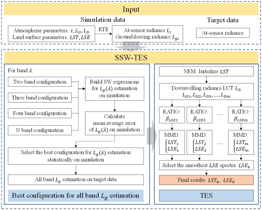
Figure 1: Workflow of the proposed method.
Lᴰ and Lᵁ are atmospheric downwelling and upwelling radiance separately. Generally, atmosphere parameters (, Lᵁ, Lᴰ) have to be decoupled from at-sensor radiance at first, and the split window method is widely used for ground leaving radiance estimation of multi-spectral data. It’s known from Eq (1) that atmospheric downwelling radiance is coupled with LSE, and atmospheric upwelling radiance and transmittance have no correlation with land surface properties, so Eq (1) can be simplified as follows:
![\[ L_i = \tau_i L_g_i + L_U_i \quad (2)\]](https://www.recentadvancesin.com/wp-content/ql-cache/quicklatex.com-6b3efd69e43bdf1fd4548dbc4b23fa26_l3.png "Rendered by QuickLaTeX.com")
where Lg is the ground-leaving radiance, including the radiance of LST and LD. It’s the fact that the atmospheric temperature changes with the altitude, and the atmospheric upwelling radiance is an accumulation of atmospheric temperature from multiple atmospheric layers:
![\[ L_U_i = \int_{H_0}^{H_1} B(T_a(x))_i \, dx \quad (3)\]](https://www.recentadvancesin.com/wp-content/ql-cache/quicklatex.com-829ad83818bf1968beed5e94c2e9920a_l3.png "Rendered by QuickLaTeX.com")
where H₁ and H₀ is the upper and lower boundary of the atmosphere, Tₐ(x) is the atmospheric temperature in altitude x. After employing the mean value theorem on Eq (3), the atmospheric upwelling radiance can be simplified:
![\[ L_U_i =\left(H_1-H_0) B\left(T_{\hat{a}}\right)_i\quad (4)\]](https://www.recentadvancesin.com/wp-content/ql-cache/quicklatex.com-7fc7b2345611959e1bfeddbb3a17d29b_l3.png "Rendered by QuickLaTeX.com")
where Tâ is the atmospheric mean temperature. So Eq (2) can be simplified by replacing LUi with Eq (4):
![\[ L_i =\tau_i L_g_i + \left(H_1-H_0) B\left(T_{\hat{a}}\right)_i\quad (5)\]](https://www.recentadvancesin.com/wp-content/ql-cache/quicklatex.com-3c92e84f5d4b8e261de04ee6571d7bb1_l3.png "Rendered by QuickLaTeX.com")
For two bands with similar ground leaving radiance, and assuming a linear relationship between the upwelling radiance, a nonlinear function using aperture radiance of two bands for accurate Tg estimation can be deduced (Zheng et al., 2019). The two-band expression is formulated as follows:
![\[ L_g_i = a_0+ a_1 L_i + a_2 \left(L_i-L_j) + a_3 \left (L_i-L_j)^2 \quad (6)\]](https://www.recentadvancesin.com/wp-content/ql-cache/quicklatex.com-b5367e3b093f560139473e24955760b2_l3.png "Rendered by QuickLaTeX.com")
where a₀, a₁, a₂, a₃ are coefficients that can be fitted out. With increasing spectral resolution, more detailed spectral information emerged, and the nonlinear expression can be applied on more than two bands to make the estimation robust. A previous study has also found that an extra vapor channel can further improve the accuracy (Wang et al., 2021), Assuming there is another band k that can be used to build another Eq (6), and the function can be formulated as follows:
![\[ L_g_i = b_0+ b_1 L_i + b_2 \left(L_i-L_k) + b_3 \left (L_i-L_k)^2 \quad (7)\]](https://www.recentadvancesin.com/wp-content/ql-cache/quicklatex.com-d660ebffe49b68a92c9237255472dfd5_l3.png "Rendered by QuickLaTeX.com")
where b₀, b₁, b₂, b₃ are also coefficients that can be fitted out, but their values are different from Eq (6). Therefore, a new nonlinear three-band expression can be deduced by combining Eq (6) and Eq (7). The new expression can be formulated as follows:
![\[ L_g_i = \hat{a}_0 + \hat{a}_1 L_i + \hat{a}_2 (L_i - L_j) + \hat{a}_3 (L_i - L_k) + \hat{a}_4 (L_i - L_j)^2 + \hat{a}_5 (L_i - L_k)^2\quad (8)\]](https://www.recentadvancesin.com/wp-content/ql-cache/quicklatex.com-de0d6850b86a938f92759fbd070643bb_l3.png "Rendered by QuickLaTeX.com")
where â₀, â₁, â₂, â₃, â₄ are fitting coefficients. Since the effectiveness of Eq (8) is mainly determined by the linear assumption between the upwelling radiance of adjacent bands, and upwelling radiance is further determined by the water vapor in the atmosphere. But with the increased spectral resolution, the stable band of atmospheric vapor radiance features can be harder to be specified. Therefore, the best band configuration for the i, j, k band of Eq (8) is obtained through trial-and-error experiments on the simulation dataset.
Moreover, the number of bands used for the ground-leaving radiance estimation can be extended to more than three channels. The function of more than three bands can be deduced in the same way as Eq (8), and the general function can be formulated as follows:
![\[ L_g_c =A_0 + A_1 L_c+ \sum_{i=1}^{m} \left( \hat{A}_i (L_c - L_i) + \hat{B}_i (L_c - L_i)^2 \right) \quad (9)\]](https://www.recentadvancesin.com/wp-content/ql-cache/quicklatex.com-732f65bbdbcb7802a63abf07aeea7d2b_l3.png "Rendered by QuickLaTeX.com")
where A0, A1, Ai, Bi are fitting coefficients, Lgc is the ground-leaving radiance of the center band, L𝑐 and Lᵢ are the at-sensor radiance of the center band and combined band.
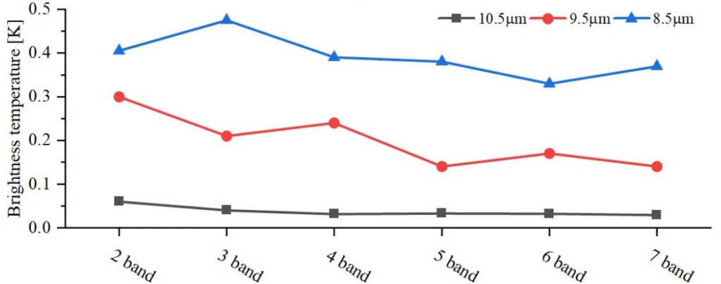
Figure 2: Error trend of SSW atmospheric compensation with different band configuration number. The atmospheric compensation error in terms of ground- leaving radiance is represented by the root mean square error (RMSE) of brightness temperature in Kelvin. The black, red, and blue solid lines represent the atmospheric compensation error results at 10.5, 9.5, and 8.5 µm, respectively.
However, the best amount for band combination can be different from band to band. For clarity, the RMSE of Eq(9) has been converted into brightness temperature in Figure 2. The result shows the best band amount for band combination is different among 8.5, 9.5, and 10.5 µm channels. Although the changing trend of RMSE is decreasing with increasing band amount, the time consumption is magnifying sharply. Therefore, after comprehensive consideration of time consumption and accuracy, the best amount of band combination for each channel is obtained through statistics on the results of different combinations.
After obtaining the Tg for each channel, only LD is coupled with LST and LSE. Since LD is also a function of atmospheric condition and varies in a certain range, a lookup table (LUT) of LD can be used to approach the appropriate spectral. Most emissivity spectra for land surface should be smooth and continuous (Borel, 1997), therefore, the smoothest LSE and corresponding LST obtained from ASTER-TES are regarded as the retrieval results.
3. Application
3.1 Data
The real airborne data used in this study was obtained from an imaging experiment conducted on March 30, 2019, in Zhengzhou, Henan Province, China, using the Hypercam LW imaging spectrometer. Hypercam LW is ×256 PV-MCT (photovoltaic HgCdTe) focal plane array detector. The spectral resolution of the airborne data used in the study was 5 cm−1, with a full width at half maximum (FWHM) of 6 cm−1. To ensure that the method was not affected by imaging spectral noise, the data range used was restricted from 870 to 1170 cm−1 (8.5 to 11.5 µm). A region located in a park was selected as the experimental area, with the spatial resolution of the chosen image being 0.95 meters. The airborne survey begins at 10:00 a.m. at local time with clear sky condition.
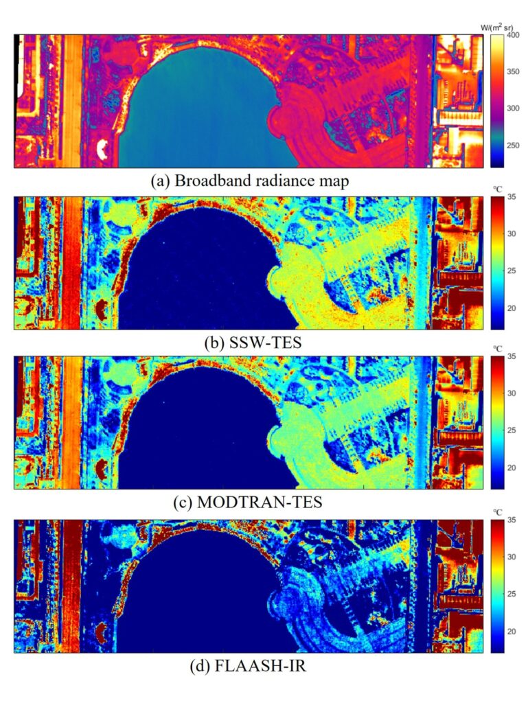
Figure 3: The LST comparison among different methods. (a) Broadband radiance map. (b) Retrieval of SSW-TES. (c) Retrieval of MODTRAN-TES. (d) Retrieval of FlAASH-IR.
During the airborne survey, simultaneous ground measurements for LST and LSE were also conducted. The EXERGEN DX501 and HEITRONICS KT15 thermometers were used to collect various surface temperatures. Both infrared temperature systems offer a temperature measurement resolution better than 0.3 K within their response range. A portable Fourier Transform Infrared (FTIR) spectrometer, model 102F, produced by DESIGNS & PROTYPES, LTD, was used to collect surface emissivity data, with a measurement accuracy better than 0.01 K. Combined with the gold plate used for measuring atmospheric downwelling radiance, the corresponding surface emissivity could be calculated.
Atmospheric profiles from the nearest sounding station and ERA5 reanalysis dataset had also been collected as the input of MODTRAN-based AC. The simulation dataset was generated from Thermodynamic Initial Guess Retrieval (TIGR) atmospheric dataset and ECOSTRESS Spectral Library based on MODTRAN and RTE (Meerdink et al., 2019; Chevallier et al., 2000).
3.2 The Results of Land Surface Temperature and Emissivity
From the results of LST based on different retrieval methods in Figure 3, the proposed method shows similar consistency with MODTRAN-TES in the homogeneous land surface, such as the lake water and marble square at the center area with low temperature, and the asphalt road at the end of the image with higher temperature. Although FLAASH-IR shows the
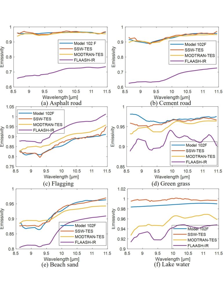
Figure 4: The LSE comparison among different methods. (a-f) represent asphalt, cement, flagging, green grass, sand, and lake water respectively.
lowest noise level, its retrieval temperature is inaccurate. For example, there is an error of 3.62 K compared with the proposed method of 0.19 K and MODTRAN-TES of 1.7 K in lake water. Because the atmospheric compensation module of FLAASH-IR is designed based on MODTRAN code and only includes 120 types of atmospheric profiles (Cone et al., 2015). Obviously, these atmospheric profiles cannot represent the atmospheric condition of the real HypercamLW data used in our study, resulting in significant errors. After checking ground measurement temperature among fifteen land surface types, including manmade roads, metal, and natural surfaces. The RMSE of the proposed method is 1.24 K, better than the MODTRAN-TES of 2.24 K and FLAASH-IR of 21.57 K. The main errors come from low emissivity metal, especially for FLAASH-IR. Among six stable ground types with validation LSE shown in Figure 4(a-f), the retrieval LSE of our proposed method is the closest to the ground measurement spectra. The maximum RMSE of the proposed method is 0.016 in the flagging sample, superior to MODTRAN-TES of 0.025 in lake water and FLAASH-IR of 0.25 in asphalt road. The errors located around 9.5 µm mainly come from ozone and carbon dioxide absorption, which are limited by available profiles when building the simulation dataset.
4. Conclusions
The proposed LST and LSE retrieval method aims to solve the problem when the atmospheric profile is inaccurate or unattainable for the LWIR hyperspectral temperature and emissivity retrieval. In real-world airborne data and ground measurement validations, the proposed method shows better performance than MODTRAN-TES and FLAASH-IR, proving the proposed method’s effectiveness and practicability.
However, the atmospheric compensation principle based on the split window method in this method does not fully leverage the advantage of the spectral band information in LWIR hyperspectral data. The experimental results presented are based on retrievals after prior band noise removal. Additionally, this semi-physical form of atmospheric compensation is limited by the differences between simulated and real-world data. The coupling relationships between atmospheric and surface parameters have not been fully exploited. Therefore, a potential direction for improving the effectiveness of such methods is to further address the model-data mismatch by utilizing the physical constraints among different parameters in LWIR hyperspectral imaging.
Autor Contributions
Du Wang: Writing, review & editing, original draft, Visualization, Validation, Software, Methodology, Investigation, Formal analysis, Concep tualization. Lyuzhou Gao: Data curation. Yanfei Zhong: Resources, Project administration. Liqin Cao: Supervision, Resources, Review, Investigation, Conceptualization, Project administration.
Declaration of Competing Interest
The authors declare that they have no known competing financial interests or personal relationships that could have appeared to influence the work reported in this paper.
Data availability
Data will be made available on request.
Acknowledgments
This work was supported by the National Key Research and Development Program of China (Grant 2022YFB3903300 and 2022YFB3903405) and National Natural Science Foundation of China (Grant 42471412). The authors would like to thank the LMD ARA group for providing TIGR dataset (https://ara.lmd.polytechnique.fr/), ECMWF ERA5 for providing
reanalysis data (https://www.ecmwf.int/).
References
Borel, C. C. (1997). Iterative retrieval of surface emissivity and temperature for a hyperspectral sensor. Technical Report LA-UR-97 3012; CONF-9705196-, Los Alamos National Lab. (LANL), Los Alamos, NM (United States).
Chevallier, F., Chédin, A., Cheruy, F., and Morcrette, J.-J. (2000). TIGR-like atmospheric-profile databases for accurate radiative-flux computation. Quarterly Journal of the Royal Meteorological Society, 126(563):777–785.
Cone, S. R., Kruse, F. A., and McDowell, M. L. (2015). Exploration of integrated visible to near-, shortwave-, and longwave-infrared (full range) hyperspectral data analysis. In Algorithms and Technologies for Multispectral, Hyperspectral, and Ultraspectral Imagery XXI, volume 9472, pages 458–469. SPIE.
Li, Z.-L., Wu, H., Wang, N., Qiu, S., Sobrino, J. A., Wan, Z., Tang, B.-H., and Yan, G. (2013). Land surface emissivity retrieval from satellite data. Int. J. Remote Sens., 34(9-10):3084–3127.
Manolakis, D., Pieper, M., Truslow, E., Lockwood, R., Weisner, A., Jacobson, J., and Cooley, T. (2019). Longwave Infrared Hyperspectral Imaging Principles, progress, and challenges. IEEE Geosci. Remote Sens. Mag., 7(2):72–100.
Meerdink, S. K., Hook, S. J., Roberts, D. A., and Abbott, E. A. (2019). The ECOSTRESS spectral library version 1.0. Remote Sens. Environ., 230:111196.
Ren, H., Dong, J., Liu, R., Zheng, Y., Guo, J., Chen, S., Nie, J., and Zhao, Y. (2020). New hybrid algorithm for land surface temperature retrieval from multiple-band thermal infrared image without atmospheric and emissivity data inputs. Int. J. Digit. Earth, 13(12):1430–1453.
Wang, D., Cao, L.-Q., Gao, L.-Z., and Zhong, Y.-F. (2024). Airborne thermal infrared hyperspectral image temperature and emissivity retrieval based on inter-channel correlated automatic atmospheric compensation and TES. Remote Sens. Environ., 315:114410.
Wang, H., Mao, K., Yuan, Z., Shi, J., Cao, M., Qin, Z., Duan, S., and Tang, B. (2021). A method for land surface temperature retrieval based on model-data-knowledge-driven and deep learning. Remote Sens. Environ., 265:112665.
Zheng, X., Li, Z.-L., Nerry, F., and Zhang, X. (2019). A new thermal infrared channel configuration for accurate land surface temperature retrieval from satellite data. Remote Sens. Environ., 231:111216.
Publisher’s Note
The statements, opinions and data contained in all publications are solely those of the individual author(s) and contributor(s) and not of Recent Advances S.L. and/or the editor(s). Recent Advances S.L. and/or the editor(s) disclaim responsability for any injury to people or property resulting from any ideas, methods, instructions or products referred to in the content.